- Research article
- Open access
- Published:
Urban historic heritage buffer zone delineation: the case of Shedian
Heritage Science volume 10, Article number: 64 (2022)
Abstract
Buffer zones help protect historical heritage sites’ integrity, authenticity, and sustainability, and thus are an essential measure for protecting such sites. Traditional buffer zone delineation considers mainly the urban texture, a rigid boundary, visual corridor construction, and other factors. A more direct approach is designating a rated outer periphery that includes historic properties as a buffer zone. However, boundaries determined by single-value orientation tend to omit protected objects. A buffer zone formed by boundary translation and enclosure will include many low-value areas in the protection scope, thereby wasting resources and affecting historic towns’ natural development, resulting in a severe contradiction between humanity and the earth. This paper proposes a new method for delimiting buffer zones. The method arises from the field that covers the value assessment of cultural heritage and from the principles of comprehensive protection, which combine cultural heritage’s tangible and intangible properties. We used 29 historical preservation plans as samples to obtain statistics on their protection content, selected natural and agriculture landscapes, architectural features, construction quality, number of stories in a building, building age, protection class, street pattern, historical elements, urban texture, cultural industry, and cultural elements according to the frequency of occurrence as the primary factors affecting a buffer zone’s boundary demarcation. These factors were weighed and evaluated by the multi-criteria decision-making method (MCDM) to create a comprehensive evaluation map for helping determine a buffer zone’s boundary. Using such method, we identified the value of historical heritage through employing the quantitative analysis method of MCDM. We also used the evaluation result to determine the buffer zone boundary objectively. This approach rectifies the problems found in previous studies, namely an incomplete accounting of all relevant factors and a lack of data; it also provides a definition of an historical heritage buffer zone.
Introduction
Recently, many historical and cultural heritage sites in China have been negatively affected by urban development, squeezed by modern urban construction. As such, they are slowly devolving isolated and scattered fragments and endangering both the protection and inheritance of urban history and culture. Every day, the expansion of both urban areas and the urban population is eroding the very environment on which these valued cultural heritage sites depends. How to ensure the inheritance of cultural values and the continuation of historical features of historic towns for their protection and development has become a serious problem for protecting Chinese historical heritage [1].
In 2008, the International Expert Meeting on World Heritage and Buffer Zones called attention to buffers as an essential topic. The document generated from this meeting, “Paper 25—World Heritage and Buffer Zones,” states: “The purpose of the buffer zone is to ensure adequate protection of designated property by adding a layer of protection to the property by imposing complementary legal and customary restrictions on its use and development.” The meeting also addressed both current and future challenges to preserving heritage sites. Additionally, the meeting recommended that the World Heritage Committee reflect the nature and function of buffer zones to ensure such zones would be used more widely for solving problems pertaining to heritage conservation [2, 3].
However, traditional buffer zones’ delineations mainly emphasize only individual factors, such as urban texture or a rigid boundary. Some heritage tourism cities delimit buffer zones based on the vision of ensuring that the historic heritage area and its surroundings have a beautiful skyline. A more direct approach would be to designate a rated outer periphery of historic properties as a buffer zone. However, a boundary determined by single-value orientation tends to omit protected objects. A buffer zone of this type—formed by boundary translation and enclosure will bring many low-value areas into the protection scope, thus wasting both workforce material and financial resources. In this kind of zone, both new construction and reconstruction would be more strictly controlled; a large buffer zone would stymie the historic town’s natural development.
Within this context, this study chose the historic town of Shedian, Henan Province, as its research object. Taking both literature reviews and statistics into account, thematic mapping of each indicator was conducted, and thematic analysis in combination with the analytic hierarchy process (AHP) was used to determine each indicator’s weight. A quantitative evaluation system of historical and cultural heritage value was also constructed with the aid of the multi-criteria decision-making method. The MCDM method is intended to promote historical and cultural heritage sites delimit clear protection boundaries for the protection and management of heritage.
Literature review
In the field of heritage protection, comprehensive conservation is common, and many international documents mention relevant content. For instance, the Athens Charter of 1933 speaks to a special consideration of heritage sites’ encompassing areas. Building on this further, the Nairobi Recommendations of 1976 stress the need for integrating historical areas and their environments into people’s social lives, as well as for adapting them to the needs of modern life. The Washington Charter, introduced in 1987, explicitly expands the scope of conservation beyond historical monuments to include historic towns and neighborhoods. The Xi’an Declaration of 2005 emphasizes the need for establishing buffer zones, thus promoting the overall protection of surrounding objects and environments related to the spiritual and cultural aspects of historical and cultural heritage sites. “Paper 25—World Heritage and Buffer Zones” (2008) states that the buffer zone helps maintain the heritage site’s integrity, authenticity, and sustainability [2]. The conference, the 2008 International Expert Meeting, encouraged heritage sites to establish buffer zones for their protection, furthering the acceptance of scholars’ methods. Notably, comprehensive protection has become a consensus, buffer zones—an essential means of comprehensive protection—also now receive more attention.
Indeed, createing a buffer zone with a specified radius around the site is an immediate and practical approach. Appendino describes historical monuments’ buffer zones in Bordeaux, France, which have a 500-m radius extending out from an historical monument; these zones are based on the idea of co-visibility and coherence with the site’s surroundings [4].
Zhang and Li propose that protecting and designing historical and cultural heritage sites, and their surrounding architectural environments, should adopt the protection mode of “circle structure,” consisting of the key heritage area, heritage protection area, and heritage buffer zone [5]. In Li and Morris’s study of Shenyang Imperial Palace’s buffer zone, they explain that the zone was mainly determined by reconfiguring the heritage’s boundary. For instance, within the Palace Museum’s buffer zone, building heights were limited and gradually reduced to ensure that high-rises remained at an adequate distance from the historical area to prevent them from upsetting the environment’s sensitive balance or from blocking the view of the historical landmarks within the area [6]. This kind of circle-layer protection method is based mainly on the distribution of historical artifacts to delimit the protection scope, which often leaves out additional valuable cultural heritage elements; it may further split the overall pattern of historical heritage and put the omitted historic buildings at risk.
In cities and towns that that prioritize heritage tourism, the government should establish buffer zones according to people’s perceptions and visual analysis to regulate the skyline, thereby highlighting the heritage’s more primary status. To this end, Darabi, Behbahani, and Shokoohi used the iconic features of the local people’s imaginations to create a buffer zone that combines perception with historical elements. This kind of buffer compensates for any shortcomings of the legal buffer, provides a more integrated context, and allows local communities to be more involved in conservation planning [7].
Mahsa Chizfahm Daneshmandian, an expert on environmental designing, deconstructs existing approaches to visual analysis techniques and then uses a combination of quantitative and qualitative methods to construct a technical platform for city planners to define visual buffer zones via height regulations [8]. Chen Feng proposes a visual control method after studying the protection of the Shang site in Zhengzhou, Henan Province, its method of definition, and the factors influencing its surrounding environment [9]. In comparison to Daneshmandian and Chen, Xie Zhouchenxi approaches heritage conservation more comprehensively. She adopts the inflexion point of the influence method to determine the heterogeneous boundary of an historical heritage site’s surrounding landscape. She does this by considering the statistics pertaining to the changing trends of culture, history, and other factors. Finally, she utilizes the element superposition method to determine an historical heritage buffer zone [10].
However, such studies on perceptions and visual analysis also have limitations. First, they essentially only consider single factors; thus it is difficult to achieve the comprehensive protection requirements. Second, while boundary divisions are evident in ideal circumstances, in actual conservation practice, it is often necessary to use streets as demarcating the actual boundaries of protected areas. Indeed, protection areas can be adverseley protected when boundaries are not aligned with street directions.
In the case of the Rhaetian Railway World Heritage site, the perception, integrity, and authenticity of the site were also accounted for in determining buffer zones (UNESCO World Heritage Centre 2008). Yuan proposes that urban plots should be subdivided according to regional historical features, building volume, style, height, urban texture, and other indicators to define homogeneous buffer zones [11]. In another study, Liu considers the historical, cultural and landscape values of Chengde Summer Resort and proposes conceptualizing and planning the comprehensive protection of the resort [12]. Although the comprehensiveness has improved, there is still room for improvement in such studies.
Historic urban landscape (HUL) are further based on comprehensive protection. The concept of HUL first appeared in the Vienna Memorandum on World Heritage and Contemporary Architecture Managing the Historic Urban Landscapes in 2005. Through a series of developments, the Proposal on Historic Town Landscapes, adopted in 2011, identifies “historic urban landscapes” as a new way of protecting and managing urban heritage. This proposal views the developed area as a multi-layered setting having both natural and cultural value, and it encompasses a broader urban context and geographical environment, which extend beyond the old concepts of “historic center” or “overall.” The 2011 proposal also suggests a comprehensive method for the identification, assessment, protection, and management of urban and rural heritage within the framework of sustainable development [13]. Much of the literature on the HUL approach focuses on historic urban areas, cultural and historic blocks, heritage protection methods, height control regarding urban buildings, the interpretation of heritage value, and more [14].
By analyzing the content of HUL, Li and Zhang extract two core concepts: “layering” and “correlation.” Moreover, on this basis, they propose an overall conservation framework grounded on multi-value layer identification, including the dynamic layer identification method of the time dimension and the overall correlation protection method of the space dimension. They thus identify the value law of the heritage site’s lifecycle. Building on this, they then carry out the overall protection of heritage sites and their associated elements [15].
Shan evaluates Tongzhou’s urban heritage and landscape value; conducts an analysis of Tongzhou’s urban heritage, using the time and space dimensions according to HUL theory; constructs an analytical framework for considering urban heritage characteristics using HUL theory; and categorizes the characteristic elements of Tongzhou’s urban heritage [16]. However, Shan’s research lacks quantitative analysis; nor is it easy to obtain clear and intuitive results by using qualitative methods to evaluate landscape value.
In yet another example, Shine et al. propose a regional development plan for sustaining Namwoneupseong Walled Town by applying the UNESCO HUL approach. They contend that, in the process of preserving the principal values of cultural heritage, the direct impact of external factors should be taken into account [17]. Using the stratification method, they review, in detail, the historical evolution of Gwanghalluwon Garden and analyze the rationale driving its preservation from social, economic, ecological, and other perspectives. However, the research is weak regarding the concrete operation of park value identification; it also lacks quantitative analysis.
Chen introduces the theory and method of “Urban Historical Landscape (HUL)” to protect and renew the design of Xiaoyan Pagoda’s historical and cultural area. From an HUL perspective, the conservation elements of historical areas are investigated to construct an easy-to-operate urban design method. However, Chen’s research focuses on historical areas, but lacks a careful consideration of society and culture in the urban background environment; it also fails to present the overall methodology framework of “cognition-evaluation-protection-management” [18].
Research on the HUL method is still in its initial stages. Scholars are conducting pilot work in cities and towns with different cultural backgrounds worldwide. However, most of the research is a partial and tentative application of the HUL method. Thus, HUL urgently needs to concretize its theoretical framework to promote practical exploration and focus on the essence of HUL as a holistic approach that accounts for both heritage management and urban development [19].
Nonetheless, research on heritage protection is continuously developing. Comprehensive protection, as a concept, has indeed changed the object of heritage protection from the oldest, single historic building to include the site’s larger environment. To this end, the buffer zone has become a vital protection tool. Along with the advancement of cognitive-based protectionism to conceptual protectionism, scholars also now employee multidisciplinary methods on the interpretation of ‘heritage site’, creating more rich concepts of heritage protection. As such, they bring into consideration factors like culture, ecology, economics, and society; furthermore, the related concept of the buffer zone has been further extended. As a method of heritage protection, HUL goes beyond the original “historical center” or “integration,” thereby extending to a larger urban context and geographical environment. Finally, this method also combines heritage protection goals with social and economic development goals, which are regarded as a more macroscopic heritage buffer zone.
Naturally, given the development of heritage protection research, the connotation of heritage value is likewise incrementally expanding. Furthermore, the requisite factors to be considered for establishing a heritage buffer zone are also changing rapidly. However, the original method fails to include quantative analysis and is struggling to meet the complex needs of heritage protection. Therefore, the academic research on the heritage buffer zone needs a breakthrough.
Case study
Study area
This study was undertaken in Shedian Town, located in the eastern part of Nanyang Basin, Henan Province, China. In 2007, Shedian Town was added to the third revision of the list of national historical and cultural towns. Shedian Town is in the east of the city, which is the old town of Sheqi County. This historic town is surrounded by developed areas in the south, west, and north, and the natural and agricultural areas directly adjacent to the town are quite small. The Pan and Zhao Rivers, which encircle the town in the southeast, flow into the Tang River to continue flowing southward. The Pan and Zhao Rivers have played an essential role in Shedian Town’s history (Fig. 1).
Notably, historic towns’ origin and development are reflected in their names. In this instance, part of the town’s name, She, means “to borrow.” It is said that Liu Xiu, Emperor Guangwu of the Han Dynasty (202 B.C.E–A.D. 220), was chased to this town. He borrowed a flag from Liu’s restaurant that had the Liu family name on it to recruit followers and defend the Han Dynasty. Later, he named the town Shedian. The name’s second part, dian, means “shop”; originally, Shedian consisted of a small ferry and a few shops. Because of Shedian’s rivers, which ensured the town’s value as a waterway transportation location, it became a commercial center on the Sino-Russian tea trade route during the Ming and Qing Dynasties. In fact, Shedian connected Fujian Province in South China to Kiakhtu, a Sino-Russian border and trade city on the north of China [20]. Furthermore, business in Shedian created a unique commercial culture. Merchants used the phrase “meeting” in their advertisements, and, in its heyday, there were monthly “meetings” in Shedian Town [21].
In the Nian Uprising of 1858, Shedian residents built brick walls parallel to the river, forming a clear boundary. Although the Anti-Japanese War in the middle of the twentieth century destroyed it, the city wall’s base is still well preserved. Additionally, there are many well-preserved historical heritages in Shedian, which are significantly representative for studying the historic towns and buildings of the Nanyang area. Naturally, such well-preserved historical heritage is a rich resource of tourism revenue. Many restaurants, shops, and souvenir shops have sprung up. Unfortunately, alongside the developing economy and society, the heritage area is actually being eroded; this creates fierce conflict over the area’s protection. What is more, the excessive protection scope has negatively affected natural residential development, making it difficult for city planners to protect the most critical areas. This has resulted in a lowered management efficiency and has stymied developing tourism centered on historical heritage. Thus, defining a more appropriate boundary for this historic area is a priority.

Location of the area of study in China
Method
A quantitative research design was used for this study. First, we selected 29 sets of conservation plans for historic towns to constitute our sampling for data collection. Based on the frequency of various protection content occurring in the plans (Table 1), we assembled 11 indicators for evaluating historical areas’ protection value [22]. Next, we determined the relative importance of the criteria and sub-criteria based on structured interviews with selected experts, and on the analytic hierarchy process created by Saaty (1980). Moreover, by using the grid interpolation tool of a geographic information system (GIS) to evaluate historic towns’ conservation value, we obtained an interpolation diagram of the conservation value evaluation. Finally, we superimposed the natural and agricultural landscapes based on a questionnaire about the interpolation diagram. We then outlined the result of the Shedian urban historic heritage buffer zone. The technical route is shown in Fig. 2.

Technical route
Determination of assessment criteria
The core of the historic area buffer zone study lies in the demarcation of the buffer scope, which is based on an accurate assessment of buffer value. Traditional buffer zones are defined mainly from the perspective of urban texture, a rigid boundary, or economic activities, or they are divided based on visual criteria to establish the dominant position of the heritage area [10]. However, the city’s circumstances are often complicated. An overall design that integrates a wider array of factors can better cope with the different problems affecting the heritage area [23,24,25].
We selected 29 protection plans for heritage areas featuring similar geographical conditions, locations, functions, and heritage protection statuses to Shedian to guide deciding on evaluation criteria. First, we summarized the protection plans’ content. We found that the plans could be divided roughly into 11 parts: status overview, value characteristics, problems, protection principles, protection objectives, protection scope, protection content, protection measures, special planning, phased planning, and safeguard measures. Among them, “protection content” aimed to safeguard heritage with outstanding value, and its core was recognizing heritage value. In this study, a buffer zone was also defined based on the total value of the heritage, and its ultimate goal was to protect the integrity, authenticity, and sustainability of heritage [2]. Therefore, we selected criteria pertaining to the “protection content” factor as the basis for buffer zone value recognition. Information collection on protection plans categorized by value elements and criteria. Value elements helped us understand the orientation of historical heritage value recognition in conservation planning, while criteria detailed which specific indicators impact heritage’s conservation value. In the operation process, first, we determined the value element and then the corresponding criteria according to the value element. We sorted the collected protection plans, recorded the frequency at which value elements and criteria occurred in the protection content of the 29 protection plans, and, finally, we identified the buffer zone value on this basis.
The value elements and criteria occurring at a rate less than 10% were considered unimportant and, consequently, were omitted from further analysis. Thus, eight value elements affecting heritage were obtained. In planning, each value element corresponds to several specific criteria. Based on the eight value elements, we used the same approach to obtain the 11 criteria (Table 1): natural and agricultural landscapes, architectural features, construction quality, number of stories in a building, building age, protection class, street pattern, historical element, urban texture, cultural industry, and cultural element.
To bring urban heritage protection into the overall sustainable development framework, we focused on the connection amount historical heritage, natural environment and cultural value. As such, the type of heritage criteria aligned with the historic town landscape method. Next, the criteria were categorized by (1) material space; and (2) historical and cultural. Table 1 summarizes the criteria gathered from the literature analysis.
The natural and agricultural landscapes directly affect the town’s external form and the internal pattern. They are also the town’s essential natural elements that ranges throughout the city, thereby providing an appropriate context for integrating heritage conservation. The architectural features are the roof’s form, building height, material, color, facade style, detail element structure, and so on. For historic towns, the architectural environment is composed of spaces and buildings on both sides of the street, and it also expresses the original historic environment and the survival of history. In the environment coordination area, the architectural style creates a model that results from the technology of the era. The feature faults of historic towns can be found through surveys, which are conducive to determining buffer zone boundaries [26].
The buildings in Shedian that date from the Ming and Qing Dynasties mostly have two floors or fewer, which easily distinguishes them, with regard to height, from modern buildings. The low-rise modern buildings are also easier to coordinate with the core protection zone’s building height. Therefore, this study considers that buildings with two floors and fewer have a relatively high value. For art historian Alois Riegl (1905), heritage buildings have chronological value. Because chronological value is formed by the passage of time, time turns “property” into “heritage,” endowing the heritage with chronological value. Furthermore, its value increases incrementally over time. Chronological value is used widely as a value source in heritage protection [27].
Buildings in the protection class are historic buildings that the government recognizes as having protection value. The historical and cultural protection level is the general classification standard in China. This classification system divides historical heritage into seven categories according to the heritages’ historical, artistic, and scientific value. For Shedian Town, there are four categories: nationally-protected buildings, provincially-protected buildings, county-protected buildings, and buildings that have neither been approved for nor announced as protection units. The buildings in the study area have been classified based according to these categories. Evaluating the protection class takes the value of historic buildings into consideration, while the cultural industry criteria in this study paid more attention to the function of architectural and cultural industry. The historical element evaluation focused on the heritage external to the building; thus, there was no problems pertaining to double calculation.
Street pattern refers to the streets in the old city with specific historical origin and scale and, as such, reflect the the lifestyles of of the citizens from a particular historical period. For instance, Shedian Town’s spatial pattern is distinctive. “Historical element” refers to the reasoning behind Shedian’s existence and development, and the important landscape it has left behind, including the old gate site, a century-old tree, an ancient well, the wharf, an ancient cellar, the city wall, and a stone archway. The relevant information was obtained from the protection planning data pertaining to the historic and cultural town of Shedian.
Urban texture analysis uses an intuitive interpretation of the textures of Shedian. The textures of any areas that have a large building volume and a low density that differs from historical textures were marked as modern textures.
“Cultural industry” refers to heritage-related industries driven by the development of historical heritage sites. Preserving related industries is also a critical function of the buffer zone, which extends the scope of Shedian’s intangible cultural heritage and promotes the heritage area’s sustainable development. Related buildings were mostly handed down from the Ming and Qing Dynasties and include cellars, antique furniture shops, and ancient apothecaries. In addition, there are some cultural and creative industries clustered around historic areas.
Like the natural and agricultural landscapes, the cultural elements were determined based on street interviews with 30 random residents. Locales in which the interviews were conducted include the gathering places of traditional customs and festivals, such as public festivals, Shehuo Festival fairs, Spring Festival fairs, the central space in which festival parades take place, fixed parade routes, and the routes’ virtual nodes. They also include the former residences of celebrities in Shedian’s history and of significance to various stories and legends, such as Liu Xiu’s borrowed flag uprising. For non-architectural objects, such as town squares, we used the building adjacent to the space as a convenient element for analysis.
Using MCDM to identify regional value.
-
(1)
Criteria weight
In the past few years, MCDM methods and processes have been addressed widely in scientific literature. For heritage assessment, MCDM is being actively researched and is garnering an increasing amount of attention [28]. The definition of the multi-criteria model for the assessment of buffer zones, which this article proposes, arises from the field that covers the value assessment of cultural heritage and from the principles of comprehensive protection, which combine cultural heritage’s tangible and intangible properties [29]. The academic literature devoted to establishing a methodological approach combines several different heritage values cited in research on decision theory [30]. For identifying a high value zone, the criteria must first be clearly defined and quantified in advance. Only then can areas that are worthiest of protection, in terms of their total value, be identified objectively.
The participation of experts has proven a reliable way to test and verify problem structure consistency and applicability (Saaty, Shih 2009; Kutut et al. 2014). For this purpose, we selected eight experts with professional backgrounds and experience in urban planning and historical heritage protection. We then conducted structured interviews based on the AHP method. Experts evaluated criteria based on the choice criteria presented in Table 1; a detailed description of each criterion was provided in written form to each expert during the interviews.
The criteria weights that reflect their relative importance were determined by the AHP method based on a questionnaire filled in by selected experts. The software program, Yaahp, was used for this purpose; it enables transparent structuring of the problem and assesses the importance of various criteria by pairwise comparisons. Once the relative importance of criteria had been determined, the total criteria values and the criteria ranking were defined to support a decision-maker in selecting the optimal solution. The software continuously evaluates relationships among answers provided by the respondents and determines the logical consistency and inconsistency of judgments, which enables the detection of either potential errors in judgments or actual inconsistency. Inconsistencies lower than 0.1 were considered acceptable.
At the interview’s end, each expert was allowed to provide an opinion and comment on the proposed model. The quantitative part of the evaluation, for each expert, resulted in the formation of a pairwise comparisons matrix:
$${\text{A}} = (a_{ij} ) = \left[ {\begin{array}{*{20}c} 1 & {\frac{{{\text{w}}_{1} }}{{w_{2} }}} & {...} & {\frac{{{\text{w}}_{{1}} }}{{{\text{w}}_{{\text{m}}} }}} \\ {\frac{{{\text{w}}_{{2}} }}{{{\text{w}}_{{1}} }}} & 1 & {...} & {\frac{{{\text{w}}_{{2}} }}{{{\text{w}}_{{\text{m}}} }}} \\ {...} & {...} & {...} & {...} \\ {\frac{{{\text{w}}_{{\text{m}}} }}{{{\text{w}}_{{1}} }}} & {\frac{{{\text{w}}_{{\text{m}}} }}{{w_{2} }}} & {...} & 1 \\ \end{array} } \right]$$$${\text{a}}_{{{\text{ii}}}} = 1,a_{ij} = \frac{{w_{i} }}{{w_{j} }} = \frac{1}{{a_{ji} }},a_{ij} \ne 0,$$aij—relative importance of criterion i compared to criterion j; aji—relative importance of criterion j compared to criterion i.
Group decision-making involves aggregating diverse individual preferences to ascertain a single collective preference. The preferences of all individuals who had assessed the stated criteria were established according to the Saaty scale. Responses for the AHP’s calculation methodology were appraised by data inputting principles and criteria assessment methodology. The relative importance of the criteria was then obtained by averaging the individual assessments of the interviewees. After the modification process, all the comparison matrices constructed based on the interviews were subjected to the consistency test.
Accordingly, results could be generated via calculation (Table 2). The indices affecting the buffer zone definitions were as follows (from the strongest to the weakest effect): protection class, historical elements, building age, architectural features, urban texture, cultural element, cultural industry, street pattern, number of stories in a building, and construction quality. Each criterion’s classification was based on the Unified Standards and Requirements for Protection Planning Drawing attachment to the Regulation on the Protection of Famous Historical and Cultural Cities, Towns and Villages (2017 Revision) [31]. The score was divided equally (from 0 to 100) according to the number of classifications.
-
(2)
Data collection
We procured a 20 m precision satellite image of Shedian Town from Google Earth as our base map and then generated vector map data of the study area in ArcGIS 10.2 for analyzing street patterns and urban texture. The data pertaining to protection class, building age, architectural features, construction quality, and the number of stories in a building were collected from Shedian’s protection plan.
The street interviews comprised a study of natural and agricultural landscapes. Forty random residents were asked to draw the natural and agricultural landscapes, as accurately as possible, which should be included in the heritage protection of historic towns on a map. The results were then collected by overlapping the maps and analyzing them by stacking frequency. Data on the cultural industry were based on field research and, according to which, we determined that Shedian Town includes many vital industries related to traditional Shedian culture, such as brewing, porcelain, and tea. For instance, shops that use traditional materials and techniques provide a traditional craft experience, and relevant widespread scientific knowledge can also be defined as cultural industry.
-
(3)
Determining the buffer zone’s boundaries
Table 2 Significance weights of criteria We generated a vector map of the research area in ArcGIS and then input the collected data of the 11 criteria into the vector graph for subsequent analysis and management (Fig. 3). The centroid points of the studied buildings and regions were generated, and the data were extracted onto the centroid points. We then used the weights in Table 2 to evaluate the data in ArcGIS to obtain the protection value evaluation.
Fig. 3 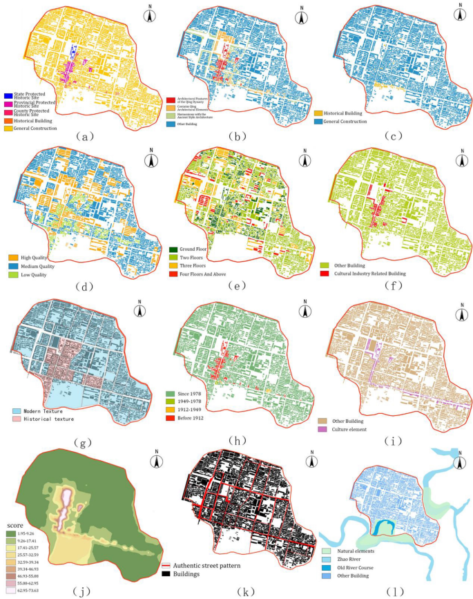
a Building protection class, b architectural style, c historical element, d construction quality, e number of stories in a building, f distribution of cultural industry, g urban texture, h building age, i cultural element, j the interpolation diagram of conservation value evaluation, k authentic street pattern, and l natural and agricultural landscapes
The natural breakpoint method was used to generate evaluation maps and classical analytical tools were used to identify regional spatial differentiation in the geographical research. The natural breakpoint method accurately identifies both natural turning points and feature points from among the data, maximizes the differences among classes, and better assesses the characteristics of individual categories [32]. However, the scoring difference among data samples was significant and the value distribution was uneven. To avoid anomalies influencing results, such as an empty class on the analysis results, we used the natural breakpoint method to divide the evaluated chart into three categories—key protection area, construction control zone, and environment coordination area—each of which corresponds to one of three partitions. Then we superimposed the natural and agricultural landscapes (Fig. 3l) and urban texture (Fig. 3g), thereby obtaining the final buffer zone boundary.

Results and discussion
Results
By analyzing the 11 criteria, we then drafted the interpolation diagram of conservation value evaluation (Fig. 3J). The conservation evaluation value chart, which contains three types, was created after processing via the natural breakpoint method (Fig. 4a). We superimposed the chart of conservation evaluation value in (Fig. 4a) and both the natural and agricultural landscapes (Fig. 3l) and urban texture (Fig. 3g). We then adjusted the zone according to the actual pattern of Shedian’s road network to arrive at the final result, namely, the buffer zone boundary (Fig. 4b).

a Conservation evaluation value chart. b The buffer zone boundary
The buffer delineation results are shown in (Fig. 4b) and are divided into three parts: key protection area, construction control zone, and environment coordination area. The key protection areas of east to Center Street (b–b′) and west to Luodian Street (d–d′) are the areas with the highest concentration of historic buildings and with the most completely preserved historical features. In this area, buildings were built mainly during the Qing Dynasty, with only a small number of buildings built during the Ming Dynasty and the Republic of China. Chinaware Street (a–a′) has the highest total value, thereby forming the key protection area.
On Central Street’s east side is a cluster of residential areas, which are comprised mostly of either renovated historic buildings or new homes based on historic designs. These sites are constituted from a mixture of historic and new construction, but locals’ homes retain the unique characteristics of Shedian folk houses, clearly displaying an historic texture. Across the street is the Shedian Distillery, which has a large volume and a protruding story. There are few historic buildings on the distillery’s east side, so the distillery is an ideal boundary for the buffer area’s environmental coordination zone (c–c′). In the north of the key protection area, Mountain Products Street (e–e′) is the main road connecting Shedian Town and the county seat, and it has both ample width and a vital traffic function. Along the north side of the street, Sheqi County government and other institutions housed in modern style are seen. Notably, the architectural scale and texture differ from buildings found in the historical center, thereby forming another natural key protection area boundary.
In addition, the model suggested that a larger area within the historic town was of low protection value and that, therefore, there were are no outstanding historic buildings worthy of special protection in that area. As the environmental coordination area of historical heritage, it provides the necessary space for developing the historic town while also ensuring a vital coordination between the features and the core protection area.
Discussion
The buffer zone’s value identification was multifaceted. This paper decided on the the protection content in the protection plans of historic towns as the standard of value identification and conducted a comprehensive evaluation of the protection value of HUL in Shedian Town.
Define the evaluation scope
This paper defines the area within the ancient city wall as the outer boundary of conservation value evaluation. There are two reasons for this:
-
1.
Shedian Town has been selected as an historic and cultural town primarily due to its unique pattern. The roads of Shedian Town constitute a grid, and the grid near the ancient wharf in the south is small. Unlike in other cities, Shanshan Guild Hall (a merchant guildhall), was located on the city’s central axis (Fig. 1). As such, it therefore occupied positions that belonged to administrative organs of varying levels in other cities, which was rare in the Ming and Qing Dynasties when the locals despised merchants. We determined the street pattern by comparing map of the Qing Dynasty (Fig. 5a) with today’s road network (Fig. 5b). Overall, there are few east–west streets in Shedian Town, and only one street crosses the town entirely. The number of north–south streets is significant, and there are fewer dead-end roads. As many as three roads run through the center of the town, which to a certain extent confirms the traffic status of the north–south thoroughfare.
The most significant characteristic of the Shedian Ancient Town’s street pattern is that it contains 72 streets and 36 hutongs, which combines the number of Tiangang and Disha (auspicious stars in ancient China), compelling one to pray for the town’s safety and prosperity. Most of the streets and parts of hutongs are well preserved. Therefore, the research and protection of historic streets are significant for maintaining Shedian’s historical features. All the patterns to be protected are within the city wall; thus, in this study, we claim the city wall as the construction control area’s boundary.
-
2.
Surrounded by the county seat of Sheqi, Shedian Town has modern urban areas in the north, west, and south, with few historical buildings remaining. Compared to the ancient town, its historical, scientific, and artistic values are insufficient to meet protection requirements. Therefore, we demarcated the city wall as the building control zone’s rigid boundary.

Historic road network and buffer zone settings a Shedian historic road network. b Shedian preserved historic road network (c) conservation planning for historic township of Shedian
Contrast with the legal buffer zone
Further buffer zone research on Shedian Town can better identify both the advantages and disadvantages of this study by comparing the results of this study with the protection planning of famous historical and cultural towns.
In 2017, the government of Sheqi County published the Shedian conservation plan of historic cities, which is shown in (Fig. 5c). Experts determined the three protection levels of the plan, and the core protection area was 38.56 ha, the construction control area was 226.08 ha, and the environmental coordination area was 738.5 ha. Additionally, the published planned decreed that building heights in the core protection zone cannot exceed 7.5 m, building heights in the construction control zone cannot not exceed 9 m, and building heights in the environmental coordination zone cannot not exceed 24 m. In contrast to the legal buffer zone in the Shedian Conservation Plan of Historic Cities (referred to simply as the Conservation Plan), in this study, the delineation of the historical heritage buffer zone was more objective, and the area allocated to buffer zone protection was more accurate.
The natural inland wharf (Fig. 3l) constitutes the fundamental reason for Shedian Town’s vigorous development and therefore has significant historical and cultural significance. Thus, the wharf is crucial for protecting the overall pattern of Shedian Town. However, currently, the wharf has undergone a baptism of urbanization; new residential buildings have replaced original historic buildings and the river has been abandoned for many years, thereby rendering it unnavigable and giving it less protection value. In light of this study’s evaluation, it was indeed classified as part of the construction control zone. However, the government’s Conservation Plan included it in the core protection area for strict protection, which is also reasonable; according to the Operational Guidelines for the Implementation of the World Heritage Convention, adjacent areas that do not have outstanding universal value but are essential for preserving areas of outstanding universal value can also become integrated with the heritage.
In this study, the building control zone (Fig. 4) overlaps with the “core protection scope” area of the protection plans, which, because of the two buffer zones, reflects a recognition of this area’s value. The only difference is that Lao Street (f–f′) had a higher protection value than the surrounding area in this study and the street was included in the building control area as a buffer zone. This was the case, even though it had no outstanding performance in the Conservation Plan and was therefore included in the building control zone alongside other areas within the city wall. There are many valuable outstanding historic relic protection units along Lao Street. Although some other historic buildings are not worthy enough to be listed as cultural relic protection units, there are many local valuable and representative buildings nonetheless. Lao Street is also a fixed route for many temple fairs in Shedian Town. It also forms a series by connecting to the historic buildings along the street, thereby forming a high-value area. Thus, this study classified it as an architectural control zone.
There are significant differences between the Conversation Plan and this study regarding the demarcation of the construction control area and the environmental coordination area. The Conservation Plan included all the towns within the ancient city walls in the construction control area. The environmental coordination area also had a broader area in the Conservation Plan, including the area in which the Pan and Zhao Rivers flow through Shedian Town and extend southward until the merging of the two rivers, to protect the unique town shape of “city and river interdependent” and to “show the mutual relationship between town walls and [the] water system pattern.”
An important contrast can also be found in that the Conservation Plan’s legal buffer zone emphasized overall protection. The entire town served as a construction control area, which could effectively protect its spatial pattern, including the street network and city wall of the Ming and Qing Dynasties. The building limit of 9 m also regulates the urban skyline, highlight Shanshan Guild Hall’s prominent position, and benefit the viewing gallery’s construction. The Conservation Plan’s environmental coordination area included a large area adjacent to the river. The area includes the Pan River, Zhao River, and their surrounding ecological areas for overall control, which can better dredge the Pan and Zhao Rivers, restore the water area of the ancient wharf, and allow for a park being built around the wall to improve the ancient town’s landscape quality [33].
However, some problems may nonetheless arise when the traditional “circle layer” method of protection scope is adopted in to protect the heritage, in patches and in general [3]. Externally, scattered historical remains and spatial texture beyond the protected area will be ignored; internally, it will cause a dearth of suitability for the reasonable development of the space’s construction. It will thus be challenging to meet the indigenous inhabitants’ needs for natural development and construction, which would, to some extent, affect the identity of both the residents and the historical environmental protection value. The “aging,” “hollowing out,” and “heterogeneity” of the heritage would also encourage the locals to demolish the heritage, thus causing irreparable damage.
The buffer zone demarcated by this study’s method is more implementable by accurately identifying each region’s value and dividing the buffer layer based on that identification. Not all traditional elements in historic towns have protection value. Traditional buildings with little value can be reasonably constructed, updated, and transformed to simultaneously inherit historical attractiveness while adapting to the needs of modern life. In this way, on the premise that the historical environment protection of Shedian Ancient Town is well preserved, suitable space for future development and construction can be carefully chosen, and the increasingly prominent contradiction between humanity and the earth could be resolved.
Shortcomings in this study
This research has some drawbacks and challenges. If the adjacent area protection value difference is too significant (e.g., Porcelain Street in the east), the key protected area will not be evenly surrounded by the construction control area. The lack of a buffer zone results in the core protection area being too close to the environmental coordination area, creating disharmony among the buildings in terms of volume, height, color, and form. In addition, the evaluation has been carried out with the centroids of buildings and streets as the carrier. A survey is therefore needed to analyze the natural and agricultural landscapes that have few buildings, such as rivers and farmland, in the environmental coordination area. While the survey respondents would choose natural areas to be protected according to their own experiences and preferences, most would be near the town and easily reached, which prevents these natural areas from including a broader range, as in the Conservation Plan, to achieve the coordinated protection’s purpose.
At the same time, this paper focuses more on the method of heritage value evaluation, and buffer zones are suggestions intended for political institutions. For the proposed protected areas, the delineation of buffer zones in this paper would have been more persuasive if experts’ opinions in political protection mechanisms had been solicited. In general, the proposed method of defining the buffer zone according to the total value of the region can indeed meet the needs of heritage protection in most historic towns, determine the protection value of urban heritage with an objective evaluation method, and determine the appropriate protection level, thereby ensuring the sustainable development of heritage.
Conclusion
The definition of the buffer zone area is crucial for the success of any protection program. The evaluation methodology developed in this study aimed to provide an objective and systematic method for evaluating urban historical heritage areas and then, based on this, to determine the buffer zone boundary.
The value of the heritage areas of Shedian Town was assessed using the MCDM method, which is composed of the weighted average of the scores assigned to the distribution of value weights of the urban historical heritage system. The criteria in this system were obtained from the statistical analysis of 29 historical heritage protection plans, and the indices whose cumulative occurrence frequency was more than 10% were retained. We assembled the buffer zone evaluation based on 11 criteria: natural and agricultural landscapes, architectural features, construction quality, number of stories in a building, building age, protection class, street pattern, historical elements, urban texture, cultural industry, and cultural elements.
The weight of each criterion was determined by the AHP method. With the AHP method, local governments can more accurately identify the value of historical heritage and surrounding areas and find an objective basis for delineating buffer zones. This would enable the planer to further convert the management measures of the three protection levels into specific actions of culture, society, policy, law, and more, according to protection needs.
Nonetheless, this method has its limitations. The analysis of heritage protection value is carried out through the building’s centroid point, so the conservation value will be underestimated when evaluating sparse architectural areas (e.g., town squares). This method is thus more suitable for the heritage value evaluation of towns and other developed areas.
In general, this method adapts better to the requirements of heritage protection in urban areas. It does so in line with the spirit of “Identification, protection, conservation, presentation, the cultural and natural heritage of outstanding universal value and transmitting it from generation to generation,” which is stated in the 2008 International Expert Meeting on World Heritage and Buffer Zones, thereby providing a reference for future heritage protection research.
Availability of data and materials
The data presented in this study are available from the corresponding author upon request.
References
Liusman E, Ho DCW, Ge JX. Indicators for heritage buildings sustainability CESB 2013 PRAGUE—central Europe towards sustainable building. Sustain Build Refurb Next Gener. 2013;2013:689–92.
World Heritage and Buffer Zones: International Expert Meeting on World Heritage and Buffer Zones, Davos, Switzerland 11–14 March 2008. UNESCO. 2009.
Fang R, Zhang J, Xiong K, Woo K-S, Zhang N. Influencing factors of residents’ perception of responsibilities for heritage conservation in world heritage buffer zone: a case study of libo karst. Sustainability. 2021;13(18):10233. https://doi.org/10.3390/su131810233.
Appendino F. Balancing heritage conservation and sustainable development—the case of bordeaux. IOP Conf Ser Mater Sci Eng. 2017;245: 062002.
Zhang Q, Li ZM. Research on overall protection of surrounding environment of historical cultural heritage. China Anc City. 2009;2:46–51.
Li Q, Yuichi F, Morris M. Study on the buffer zone of a cultural heritage site in an urban area: the case of Shenyang imperial palace in China. WIT Trans Ecol Environ. 2014;191:1115–23.
Darabi H, Irani Behbahani H, Shokoohi S, Shokoohi S. Perceptual buffer zone: a potential of going beyond the definition of broader preservation areas. J Cult Herit Manag Sustain Dev. 2020;10(3):271–91. https://doi.org/10.1108/JCHMSD-12-2017-0087.
Daneshmandian MC, Behzadfar M, Jalilisadrabad S. The efficiency of visual buffer zone to preserve historical open spaces in Iran. Sustain Cities Soc. 2020;52:101856. https://doi.org/10.1016/j.scs.2019.101856.
Feng C. Study of the range of heritage’s setting-a case study on the city wall of Shang Dynasty in Zhengzhou Xi’an University of Architecture and Technology. 2009.
Xie ZCX. Study on delineation and evaluation of buffer zone in historical and cultural blocks Southwest Jiaotong University. 2018.
Yuanyuan. Protection and renewal of contemporary historical and cultural conservation areas—a case study of overseas Chinese new village in Guangzhou. Archit J. 2010;6:28–31.
Liu JF. The overall protection and organic renewal of Chengde Summer Resort and surrounding temple urban space. Tianjin University. 2003.
Yuyun L. The strategy researching of protection and regeneration on historic district under the view on the concept of historic urban landscape. In: Hanzhong Dongguan historic district as an example. Southwest Jiaotong University. 2016.
Caballero GV Pereira Roders A. Understanding trends on urban heritage research in Asia. In: 2nd International Conference on Urban History: Cities in Europe, Cities in the World, 3–6 September 2014, Lisbon, Portugal.
Heping Li, Xuchen Z. Research on the protection of historical and cultural cities in the perspective of historic urban landscape: a case study of daming ancient city of Ming and Qing dynasties in Hebei. Dev Small Cities Towns. 2019;37(1):102–12.
Chao S. A study on conservation and utilization of the urban heritage of Beijing sub-center Tongzhou. Beijing University of Civil Engineering and Architecture. 2020.
Shin HS, Chen Y, Lee WH, Kim DH. Sustainability of historical landscape to Gwanghalluwon garden in Namwon city, Korea. Sustain. 2015;7(7):8565–86. https://doi.org/10.3390/su7078565.
Siyu C. A study on the method of site survey and analysis in historic area from the perspective of HUL. Xi’An University of Architecture and Technology. 2020.
Quhang Wu. Review on the research on historic urban landscape theory and approach. Urbanism Arch. 2021;18(07):188–93.
Yu H. The research of Wanli tea ceremony and its towns in Central China of Qing Dynasty. Zhengzhou University. 2019.
Yingying X. The Ming and Qing Dynasties guild regulations studies—take the Shanxi and Shanxi Huiguan as the example. Shandong University. 2008.
Dong R. Conservation planning evaluation of historical and cultural towns and village. South China University. 2021.
Daneshmandian MC, Behzadfar M, Jalilisadrabad S. The efficiency of visual buffer zone to preserve historical open spaces in Iran. Sustain Cities Soc. 2019;52(1):1–13.
Darabi H, Irani BH, Shokoohi S, Shokoohi S. Perceptual buffer zone: a potential of going beyond the definition of broader preservation areas. J Cult Herit Manag Sustain Dev. 2020;10(3):271–91. https://doi.org/10.1108/JCHMSD-12-2017-0087.
Schlee MB. The role of buffer zones in Rio de Janeiro urban landscape protection. J Cult Herit Manag Sustain Dev. 2017;7(4):381–406. https://doi.org/10.1108/JCHMSD-10-2015-0040.
Hanwu Z. Research on the coordination of historic towns based on symbiosis theory—taking the renewal of Anren Ancient Town to the Republic of China Street section as an example. Southwest Jiaotong University. 2018.
Ping C. A. Riegl and Art Science. Hangzhou: China Academy of Art Press. 2002.
Dadras M, Shafri HZM, Ahmad N, Pradhan B, Safarpour S. A combined fuzzy MCDM approach for identifying the suitable lands for urban development: an example from Bandar Abbas, Iran. J Urban Environ Eng. 2014;8(1):11–27.
Zapolskytė S, Vabuolytė V, Burinskienė M, Antuchevičienė J. Assessment of sustainable mobility by MCDM methods in the science and technology parks of Vilnius, Lithuania. Sustainability. 2020;12(23):9947. https://doi.org/10.3390/su12239947.
Saaty TL, Shang JS. An innovative orders-of-magnitude approach to AHP-based multi-criteria decision making: prioritizing divergent intangible humane acts. Eur J Oper Res. 2011;214(3):703–15. https://doi.org/10.1016/j.ejor.2011.05.019.
Regulation on the protection of famous historical and cultural cities, towns and villages 2017 Revision. Zhonghua Renmin Gongheguo Guowuyuan Gongbao. 2017.
Wenbo Xu, Wenjuan YU, Shaocai J, et al. Debris flow susceptibility assessment by GIS and information value model in a large-scale region, Sichuan Province (China). Nat Hazards. 2013;65:1379–92. https://doi.org/10.1007/s11069-012-0414-z.
Lee MY, Hitchcock ML, Wengsi J. Mental mapping and heritage visitors’ spatial perceptions. J Herit Tour. 2018;4(13):205–319.
Acknowledgements
The authors would like to thank Yuan Xin and Zhang Hanxue for their editorial guidance.
Funding
None.
Author information
Authors and Affiliations
Contributions
LR: methodology, software, validation, formal analysis, investigation, data curation, writing—original draft. LY and KD: writing—review and editing, supervision. ZL: consulting on research content and contact experts. All authors have read and agreed to the published version of the manuscript. All authors read and approved the final manuscript.
Corresponding author
Ethics declarations
Competing Interests
The authors declare that they have no known competing financial interests or personal relationships that could have influenced the work reported in this paper.
Additional information
Publisher's Note
Springer Nature remains neutral with regard to jurisdictional claims in published maps and institutional affiliations.
Rights and permissions
Open Access This article is licensed under a Creative Commons Attribution 4.0 International License, which permits use, sharing, adaptation, distribution and reproduction in any medium or format, as long as you give appropriate credit to the original author(s) and the source, provide a link to the Creative Commons licence, and indicate if changes were made. The images or other third party material in this article are included in the article's Creative Commons licence, unless indicated otherwise in a credit line to the material. If material is not included in the article's Creative Commons licence and your intended use is not permitted by statutory regulation or exceeds the permitted use, you will need to obtain permission directly from the copyright holder. To view a copy of this licence, visit http://creativecommons.org/licenses/by/4.0/. The Creative Commons Public Domain Dedication waiver (http://creativecommons.org/publicdomain/zero/1.0/) applies to the data made available in this article, unless otherwise stated in a credit line to the data.
About this article

Cite this article
Lv, R., Liu, Y., Zhang, L. et al. Urban historic heritage buffer zone delineation: the case of Shedian. Herit Sci 10, 64 (2022). https://doi.org/10.1186/s40494-022-00702-9
Received:
Accepted:
Published:
DOI: https://doi.org/10.1186/s40494-022-00702-9